We started out on our trip early on Friday September 3. We were headed for Kamloops that night, so we decided to start out earlier, as we were going to be meeting a couple of the fire information officers for the fire centers located in Kamloops. Since we arrived in Kamloops early, we decided that we would head to Mr. Mikes Restaurant, and then we still had some extra time, so we headed for William McArthur Island Park, and this is a very neat park. There are so many activities that happen within this facility. There is baseball, track and field, walking etc. We then headed to the fire centers, and we were just expecting to meet these officers, instead they were able to show us around, and show us what happens during the typical fire season. It was very informative.
|
We started out on our trip early on Friday September 3. We were headed for Kamloops that night, so we decided to start out earlier, as we were going to be meeting a couple of the fire information officers for the fire centers located in Kamloops. Since we arrived in Kamloops early, we decided that we would head to Mr. Mikes Restaurant, and then we still had some extra time, so we headed for William McArthur Island Park, and this is a very neat park. There are so many activities that happen within this facility. There is baseball, track and field, walking etc. We then headed to the fire centers, and we were just expecting to meet these officers, instead they were able to show us around, and show us what happens during the typical fire season. It was very informative.
0 Comments
 We went over on the very early ferry to the Island via Tsawwassen. We went to Duke Point, and we took the early ferry at 5:15 a.m. We arrived at Nanaimo a little after 7:30 a.m. and we then went down to fill up with gas before we went to the Lake Cowichan area.
We went to Mesachie Lake, where the turn off for the road we took which was the Harris Creek road. We took a look a giant Sitka Spruce tree, named the Harris Creek Sitka Spruce Tree. On the Victoria Day weekend (sunday May 23), we set out for our excursion about 4:30 p.m. I had to work until this point, so we couldn't leave until I was finished.
We went through the Fraser Valley past the turn off to Agassiz, and the Dino Park, as well as the Trans Canada waterslides. We then got to the Coquihalla Highway, and just as we were going up near the foot of the highway, we saw a black bear walking along the side of the highway. We continued on further up the highway, and ran into some snow on the sides of the road. The temperatures were not very warm, as there was a cold front that had gone through before we got to the Coquihalla area, which cooled things down significantly. At the Coquihalla Summit it was between 1 and 4 degrees celcius. We stopped at the Britton Lakes Rest Area, formerly around where the toll booth was. At this rest stop we came across some birds known as "brown headed cowbirds." We continued further on, towards Kamloops on the look out for some more wildlife, but we were not able to see anymore that night. Chilliwack Lake Trip
We went on this trip on Good Friday, which was Friday April 2, 2010. We left on this trip about 8 a.m. in the morning, and decided to head to the Fraser Valley region namely to the Chilliwack area. This area can be very beautiful, but it was quite cool, as well as snow showers off and on around the Chilliwack Lake area. As soon as we got to the area of the Trans-Canada Highway, that we could turn off onto, which was the Vedder Crossing, we got to go on a fair stretch of road, passing the entrance to the road of the ever popular Cultus Lake Provincial Park, and we continued on until we got to the fork in the road, which one way would lead into Downtown Vedder, and then the other direction led us to the Chilliwack Lake/River area. We went down the long road, in order to view some of the lake. Along the way, there are many recreational sites that are easily accessible when the weather is better, but at this moment in time, it was very cold, and very windy. This road took us past the monumental Mt. Sleese plane crash site, as well as one of the DND branches. There are numerous forest service roads that are in the area too, but due to the weather, we were only able to tackle a couple of them. Squamish/Whistler Trip
We got up very early at like about 4:30 a.m. to travel to the Squamish and Whistler area on Saturday March 27, 2010 for our first back road trip, again for the mission of finding wildlife. We were fortunate to see and hear lots of birds, and we also saw a couple of deer, but we didn’t see too much else at this point in time. The first point of travel was to Garibaldi Provincial Park area. Please note that at the present time, that you must enter Garibaldi Park area via to the Diamond Trailhead through the Quest University Road. The Lower Mamquam Road has a washout on it, and travel is unadvisable in this, area, and as well, you will notice a road closed sign put up by the Squamish District. If you do however try to go through, you will go through at your own risk. We went up to the Diamondhead Trail Head and were greeted with the presence of snow falling as we headed higher and higher into the mountains towards this area. Please note that they do keep this road plowed during the winter to allow those who want to backcountry ski to get up to this area safely. As a note of what I saw on the travel boards at the foot of the trail head was information regarding avalanches, bear safety etc. Please heed to all of these warning accordingly. Please also note that this is a self sufficient park, meaning that you need to have necessary safety gear etc. Also, please try and practice no trace hiking and camping, so that others can enjoy the same sites that you may enjoy. On our way down from the trailhead, we were fortunate to see some stunning sites of the coastal mountains, and of the Sunshine Coast etc., so we took some pictures.  We went to Mile High Resort, that is located in the heart of the Cariboo around Logan Lake. It is approximately 20 km from Highway 5 aka the Coquihalla Highway via Exit 336.
We arrived late in the evening on Friday October 9th, and then we stayed until Monday October 12. It took sometime to get settled into the cabin, as it is one of those cabins where you have to bring all the equipment with you. The particular cabin that we were staying in was a large airy cabin. There were 3 of us that were there on Friday night, and then the rest of our party arrived on Saturday morning. It was so cold up there starting the first night that we were up there. It was good that we brought our wool and fleecy wear with us, as we needed it. The first morning that we were up there, it was clear, but VERY cold. At night, it would be close to -16. Despite the really cold temperatures, we were still able to enjoy fishing, exploring through the back roads, and hike around. To show you how cold it was, the entire lake shore was frozen. We went to Dominic Lake, which was located on a back road,and then we also went to Paska Lake too which had significant freezing on it. We also were able to see lots of rabbits, whiskey jacks and deers when we were up here. For more information regarding the Mile High Resort, please refer to their resort page. Stay tuned for more trip information! Trip of 2009 to Northern British Columbia
We start our journey early on Saturday morning of July 25, 2009. We head up to the Sea to Sky Corridor along Highway 99. We go on the newly constructed highway, with some minor delays along the way. There were the odd 50 Km per hour signs that we come across on the highway. We then get up to the area around Whistler and Squamish, and there is beautiful scenery around the lakes and also the mountain landscape was also very appealing. We were actually able to see the trailhead for the Brandywine Falls instead of a fully covered with snow landscape. We continue our way through Whistler, and past Green Lake, and then we head onto the Duffey Lake connector. 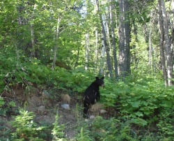 July 1, 2009  This is some of the Nathalatch Forest Service Road. Boston Bar Trip April 10, 2009 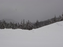 March 28, 2009 |
Archives
September 2010
AuthorWe love travelling to different remote places within the province. Check back fairly frequently to see if there are any other stories. Categories |
 RSS Feed
